Thank you to everyone who reads our blog!
May 20 (Day 23), Cont.
The wind picked up as we left Kliktsoatli Bay, so we sailed out to Seaforth Channel. After several hours, we rounded Ivory Island Lighthouse and turned into Mathieson Channel. We arrived at Perceval Narrows, the tight waterway between Lady Douglas and Lake Islands, a couple hours before slack tide. In narrows this calm and straightforward, transiting early was easy.
The wind died farther inland, so we turned on the motor to keep moving and arrive at our anchorage, Rescue Bay, before dark. Shallow, wide, and well protected from all winds, Rescue Bay is described as the best anchorage in Mathieson Channel, yet we had it all to ourselves.
Rescue Bay is tucked up between Roderick and Susan Islands, two known locations of spirit bears. Spirit bear or not (in our case, not), the bay was beautiful.
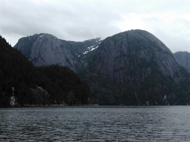
 |
| Mathieson Channel |
 |
| Mathieson Channel |
 |
| Rescue Bay Anchorage |
May 21 (Day 24)
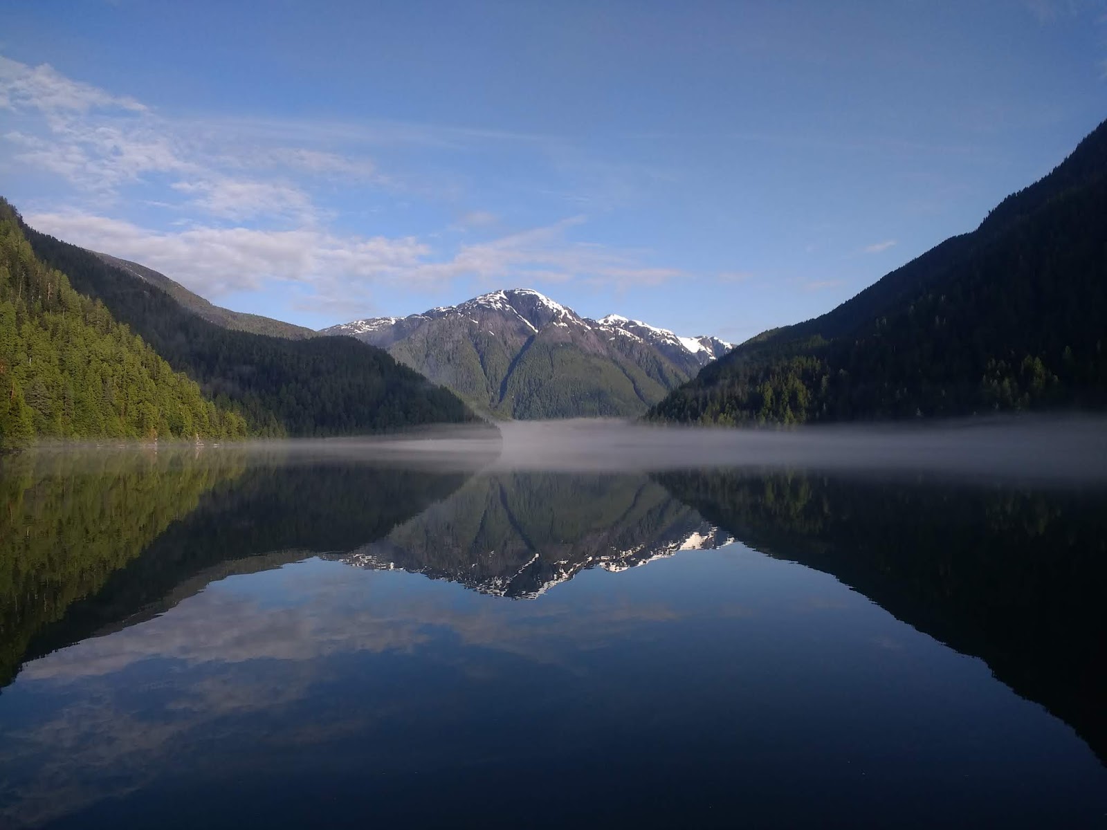
We took this route to explore Fiordland, a fortunate last-minute decision.
Fiordland Recreational Area is rarely visited and we can’t understand why. It’s only slightly out of the way of the main Inside Passage drag and definitely worth the detour. We cannot recommend Kynoch Inlet and Culpepper Lagoon enough.
The size and beauty of Fiordland are unlike anything we’ve experienced by boat. As soon as we rounded Kynoch Point at the entrance of Kynoch Inlet, everything got bigger. Snowcap mountains enveloped us. Behemoth cliffs of marbled granite rose vertically from the shore over a thousand feet high. We were awestruck.
Our Waggoner Cruising Guidebook shares our sentiment: “On a coast filled with unspeakable beauty, no places we have seen surpass Kynoch Inlet. Most fall well short. Words such as awesome, incomparable and magnificent suggest but do not capture the grandeur of this inlet.”
I hope our pictures do it justice where words cannot.


 |
| Kynoch Falls |

 |
| Kynoch Inlet |


After the elbow in Kynoch Inlet’s halfway mark, winds tumbled down through every valley. The surge of winds and narrow granite walls created a confusing barreling effect through the fjords, but we were thrilled to have wind and thrilled to be sailing again!
At the end of Kynoch Inlet, hidden Culpepper Lagoon begins. We would miss the opening if we weren’t looking for it. Due to the shallow rapids, we knew we had to enter right at high water slack. We checked our sources to determine when that occurred but couldn’t find a clear answer. One source said to time it with Bella Bella’s slack; another suggested 30 minutes before; one swore by matching Hiekish Narrows (10 minutes after Bella Bella); and yet another, 10 minutes later.
Bella Bella’s highwater slack occurred at 7:29pm. We arrived about at 6:45 so Dave could explore the entrance closeup by kayak first. He held onto De Novo like a sidecar, and I launched him outside of the entrance where he paddled closer than Novi could go. When he returned, he reported we were nearing the end of the flood, but the water seemed calm enough to transit; by entering soon, we would get a slightly favorable current.
 |
| Unmelted snow from an avalanche |
 |
| Sidecar |
 |
| Scouting it out |
We waited until a little after 7 to be sure. One source reported shoals on the north side, so we hugged the south side. After passing the main narrow way, we hugged north to avoid the whirlpools and rips at the south point. But we made it and in doing so, entered our own secluded, enchanting world. Tolkien-like peaks towered above us on all sides.
Culpepper Lagoon is magical, but it’s also mysterious and poorly charted, a Bermuda Triangle of Cascadia. In fact, when anchored at Rescue Bay the night before, we noticed a ship in Kynoch Inlet on our AIS, appearing on the screen one moment and disappearing the next, something that doesn’t generally happen on a working ship-to-ship transceiver. We lost them indefinitely when they approached Culpepper Lagoon.
Despite useless electronic and paper charts, we found a good anchorage just south of Lard Creek in about 9-10 fathoms and tied a stern line to shore.


May 22 (Day 25)
The rain was heavy this morning and didn’t let up by early afternoon, but we knew we wouldn’t have another chance to explore Culpepper Lagoon. We donned our long underwear and foulies and headed out in our kayak.
We beached it on mud flats just next to Lard Creek. The ground was soft and deep, and thank goodness we wore our muck boots. With every step, we sunk past our ankles. Regardless, we followed the smell of sulfur inland about a couple hundred yards, curious about the source. A hot spring maybe? Sulfur springs?
While we didn’t find hot springs, we did find bear tracks. LOTS of them. Big ones. In all directions. We concluded the mud flats must be prime clamming territory for the bears around here. The grizzlies were shipped to this area when they got too close to humans in Kitimat. “Friendly” grizzlies are the worst kind to encounter because they have no fear of people. And while we were armed with an airhorn and bear spray, we did not want to stick around to see if they worked!
We were nearly back to the kayak when my boot sunk down past my calf and I fell backward. I was covered in mud. Full backside, up the sleeves, up the pants, my gloves, my liners, everything in sticky, sulphuric soup. Dave helped me up and back to the kayak, but I couldn’t get in like this. So instead, I washed myself clean. In the water. Right off the ice-cold creek. Did I mention it was raining? I had to consistently move my feet, not only to keep from freezing but also to keep from sinking.
Once onboard, I could not turn on the diesel heater fast enough! If the only difference between an ordeal and an adventure is attitude, then I was determined to count this an adventure. J


 |
| Squint and you can see Dave |
 |
| Bear Tracks |
 |
| Floating on clouds through the night |
May 23 (Day 26)
Our VHF wouldn’t get a weather channel—or any channel for that matter (Bermuda Triangle)—but the fog had lifted and the sun had come out. Perfect weather for returning to the Inside Passage.
We arrived back at the rapids just after Bella Bella’s 8:37am high tide. We checked our 2018 tides and current book and found our transit aligned with the Hiekish Narrows slack. Anyone considering Culpepper Lagoon, we suggest timing it with Hiekish Narrows. It was completely smooth, not even a ripple. Looks like Waggoner correspondent Gil Flanagan wins the award for most accurate source. Go Gil!
 |
| Fog lifting in Culpepper |
 |
| Completely calm at the narrows -- and a difficult exit to find |
There were no winds in Kynoch and Mathieson this time, so we motored. Finally, we felt a slight breeze at the entrance of Sheep Passage, so we turned off our engine and waited. Just then, we heard a loud whoosh. A whale just a few hundred yards from us! A humpback maybe? He nonchalantly logged up toward Mussel Inlet, giving our drifting boat a wide berth. Sorry we never get whale pictures; they just look like black dots on our cameras.
 | ||
Sheep Passage
|

Once he had passed, the wind picked up again and we were moving! It lasted to Graham Reach, where we turned on the engine once again to pass Hiekish Narrows. Engine on. Engine off. This is how we put put up the coast.
After an 11-hour leg, we anchored west of the Green Spit in Khutze Inlet (pronounced “Kootz”). Difficult to find a good place to anchor, but gorgeous!
 |
| Waterfall in Graham Reach |
 |
| Heading into Khutze |
 |
| Our Khutze Anchorage |

Dolphins greeted us as we reentered Graham Reach. We’re used to seeing harbor porpoises out here, but dolphins are rare. We had no bow wave to ride, but they darted around our boat so fast!
Dave learned about the Klekane Hot Spring from the BC Parks website, yet it wasn’t mentioned in any cruising guide. In fact, most of our sources called Klekane Inlet a poor to fair anchorage at best, but we were determined to soak tonight.
We found anchorage at the head of Klekane Creek in about 60 feet. According to our Navionics chart though, we were in shallow tidelands, and our swinging radius was clear onto land. Hmmm…It appears all the best places are poorly charted. We were at extreme low tide and had checked our full swinging radius, finding soundings of 32-104 feet, so we felt safe.
The extreme low tide at the creek meant we had to paddle against the current to shore. When the creek got too shallow to paddle, we had to carry it a quarter of a mile up into the tidelands. Since all of it floods at high tide, and we didn’t know how long we’d be at the spring, we knew we needed the kayak as close to the tub as possible for the way back.
We curved off the main creek and noticed the water warmed up at our sandals. We tied our kayak up and hiked a brief, marked trail to a cedar structure. The tub inside was private, hot, clean, and everything we wanted. Definitely worth it.
 |
| Bliss in Graham Reach |
 |
| Klekane Inlet: beautiful, but not well protected |
 |
| Carrying the kayak |
 |
| Hot spring |
 |
We planned to soak during high tide this morning, but the seas had a different plan.
As we drank our coffee and prepared our breakfast, our anchor alarm went off. At high tide with plenty of scope, and no sound from our anchor, the only explanation is that we didn't scope out the shallows well enough last night. Our depth showed 35 feet…then 28…23…18...lowering. Here we go!
Oatmeal still on the stove, I motored back to deep ground while Dave pulled up the anchor. Then wind increased. 20+ knots up the channel. Once Dave had the anchor up, I got us upwind a bit.
But we still needed to pull in the kayak. It can’t drag behind us like big dinghies because it floods. I slowed the engine so Dave could hook up the halyard to the kayak, but he couldn’t reach the kayak chair. With the boat back in neutral, we started to drift downwind to shallow water again. But if I put us in gear to speed up, the kayak’s transom flooded and we’d lose the chair.
The chair went overboard anyway, so after Dave pulled up the kayak, we went back for it. I lined it up with our beam, and Dave pulled it up with the boat hook. This wasn’t the way we expected the morning to go, but at least we could practice a man chair overboard drill! We stand by our comment from yesterday: the hot spring was still definitely worth it.
Strangely, winds calmed down back in the main passage, and we sailed on a nice, slow downwind run for several miles. It gave us just enough time to catch our breath before the high winds started up again in the crossroads between McKay Reach and Ursula Channel.
We continued north up Ursula to Bishop Bay Hot Springs. Anchoring is not easy in the bay, and we didn’t want another repeat of this morning’s fiasco, so we were relieved to find one of the three public buoys open. After a day of cold rain, another night of hot springs felt just right.
Bishop Bay Hot Springs are special. Boaters carve their boat names and year(s) they visit in the wood, bring their own wood panel, or hang a buoy or other apparatus from the rafters above the inside spring. Hundreds of names. We didn’t know to bring anything, so the other couple in the springs, John and Shannon from SV Gypsy Woman, were kind enough to let us use theirs. They hung a buoy the first year they came and added the year in sharpie every year since. Now it also reads “SV De Novo 2018.” We’ll need to add additional years in the future, of course. J
 |
| Fraser Reach |
 |
| Dave in the outer pool; notice the fenders above |

May 26 (Day 29)
The morning was cold and rainy, and visibility was poor. But winds funneled into the bay, so we knew it was time to leave.
 |
| Bishop Bay |
We planned to sail upwind (south) in Ursula Channel and across McKay Reach to move westward and eventually north. However, once we were out in those seas, with 25 knots on our nose, we chose to turn north up Ursula instead. 18-20 knots on our back was much more comfortable.
 |
| Ursula, heading north in calmer seas |
Once we entered Verney Passage, however, the winds unexpectedly died. We were helped by a two-knot current, so we drifted…at two knots. The rain was so thick we could barely see the rock cliffs around us. And it wasn't fun. Cold, sharp drops just pummeling us, pelting us sideways. This no longer felt like a leisurely sail, so we turned on our engine and headed straight for Hartley Bay.
 |
| A rare moment of clarity in Verney Passage |
Apparently, everyone else had the same idea, and the docks were full. Dang. Coghlan Anchorage (the passageway between Promise Island and the mainland) was the only place in the area to set the hook, and it had mixed reviews in our cruising book. The shipwreck in the channel wasn’t a good omen. As a shortcut for commercial vessels heading north from Wright Sound, the anchorage would be bumpy. But without better options, we dropped the anchor and got ready for bed.
Silly us. We anchored on rock.
The anchor alarm woke us around midnight. We had dragged about 50 feet over five hours, and we needed to reset it. But we really didn’t want to deal with it. Our foulies and other raingear were dripping in the head, and even our long underwear was still damp. It was so stormy out there yet our bed was so warm.
Here we go. We donned our soggy layers and headed out to the deck. The winds picked up, and we noticed 24 knots on our aeronometer. Not great for re-anchoring. Dave braved the winds at the anchor while I motored toward a big patch of gravel-sand (GS) on the chart. With the rain blocking the stars, the dark was disorienting and even a bit eerie.
With the anchor reset, we waited and listened. When we were sure the anchor was quiet, we slept hard.
May 27 (Day 30)
By morning, the public docks at Hartley Bay were still crowded, but Monique and Wynn on MV Christina Rose kindly offered to let us raft up to them and string our power cord across their cockpit. Thank you, MV Christina Rose! The winds are screaming outside, but we are nice and cozy inside with our dehumidifier and space heater running.
Hartley Bay is a Gitga'at First Nations community of around 170 people. It is a dry community (no alcohol) and includes a church, community center, school, and public wharf, all located along the seaside boardwalks. If residents drive, they use small ATVs and Smart Cars, as traditional vehicles are too heavy for the boardwalks. Once the rain clears a bit, we look forward to exploring it.
On a separate note, happy birthday to my (Denise's) dad! Thank you for your unwavering encouragement and love. We hope your birthday is wonderful.
On a separate note, happy birthday to my (Denise's) dad! Thank you for your unwavering encouragement and love. We hope your birthday is wonderful.


